
Zion National Park recorded 5,039,835 visits in 2021, the first year its annual visitation exceeded five million, and it still received 4,623,238 visits in 2023 according to the National Park Service visitation record. That scale changes how you should plan a hike. Zion isn't an open trail network where you can drive up, find a space, and choose a route on impulse. It's closer to a timed-entry museum built into a canyon, with transportation, permits, river flow, and weather determining what you can do.
You might reach Springdale early, see a line forming for the park shuttle, and realize that the trail you ranked highest isn't the best choice for the day. A permit window may not match your arrival, the canyon shuttle may shape your return time, or river conditions may rule out the Narrows. This Utah Zion National Park travel guide and hiking tips article treats those details as the foundation of the trip, not as footnotes after the trail rankings.
Introduction to Zion and Why Planning Matters More Here
Zion received more than five million visits at its peak, and annual visitation rose from about 2.6 million visits in the early 2000s, an increase of roughly 90 percent, according to the park's historical visitation statistics. That scale makes logistics part of the hike itself. A route can fit your fitness level and still fail if the parking plan, shuttle queue, permit window, or trail conditions do not line up.
A first morning in Zion often reveals this before you take a single step. You leave your lodging in Springdale planning to hike Angels Landing, then find that transportation controls your start time and return time. If your permit window and shuttle timing conflict, choosing a shorter route may be wiser than rushing the original plan.
The canyon works like a scheduled system
The Zion Canyon shuttle began operating in 2000. By 2002, annual shuttle boardings reached 2.35 million, nearly matching that year's 2.61 million park visits, and the system later surpassed 90 million total boardings, as documented in the history of Zion's shuttle system. Those figures help explain why The Grotto, Weeping Rock, and Temple of Sinawava function as transit stops as much as trailheads.
Begin with access, then check the permit type, and then review conditions that could close or limit the route. River flow can determine whether a water hike is appropriate, while shuttle timing can decide how much daylight remains. Your fitness matters, but it is only one part of the decision.
Practical rule: Plan Zion in this order: access, permit, conditions, trail, and only then pace.
This order keeps transportation from consuming the morning and prevents a rushed finish on a trail that needs more time. It also gives your group a usable backup. If a signature hike does not work that day, choose a scenic walk or lower-commitment route that matches the available time and conditions.
When to Visit Zion for Weather Crowds and Trail Conditions
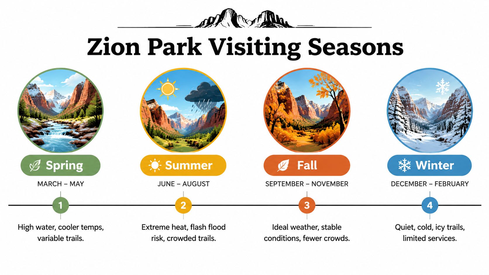
Zion has four distinct visiting seasons, but the calendar alone cannot choose your hike. Your route depends on the conditions that control it: river flow for water hikes, heat and exposure for climbs, and operating conditions for reaching the trail. Select dates by the day's logistics, not fitness alone.
Choose dates by your primary objective
A season is a broad label, like a trail sign that points generally uphill. Water temperature, discharge, heat, crowding, and ice provide the details needed for a safe choice.
- Spring: Cooler air can make walking pleasant, while runoff may raise river flow and create variable trail conditions. Check water levels and closures before choosing a water route.
- Summer: Long daylight helps, but heat, heavy demand, and monsoon-related canyon risk can change the plan. Start early, protect yourself from intense sun, and take weather alerts seriously.
- Fall: Often offers a useful balance of comfortable hiking and more stable conditions. It can suit visitors who want to spend more time on the trail without peak-season pressure.
- Winter: Quiet conditions may appeal to photographers and hikers who value solitude. Prepare for cold and ice, and expect reduced services that make a flexible itinerary more practical.
For river routes, discharge matters more than the season's name. For exposed climbs, heat and crowding affect comfort, pace, and when to turn around. A permit-heavy schedule also leaves less room for changes when conditions shift.
Peak-season demand is especially apparent from May through July. Arriving early can affect whether you start in manageable temperatures and return with enough time for transportation. Weekdays and shoulder-season dates may reduce pressure, but current operations still need checking.
Before departure, review National Park Service Zion travel information, then compare the forecast with the route's exposure, crossings, and permit requirements. Travelers planning other western parks can apply the same method through this Glacier National Park travel guide and tips. In Zion, the strongest plan is the one that matches the season, the route's threshold, and the access available that day.
Getting There Parking and Riding the Zion Canyon Shuttle
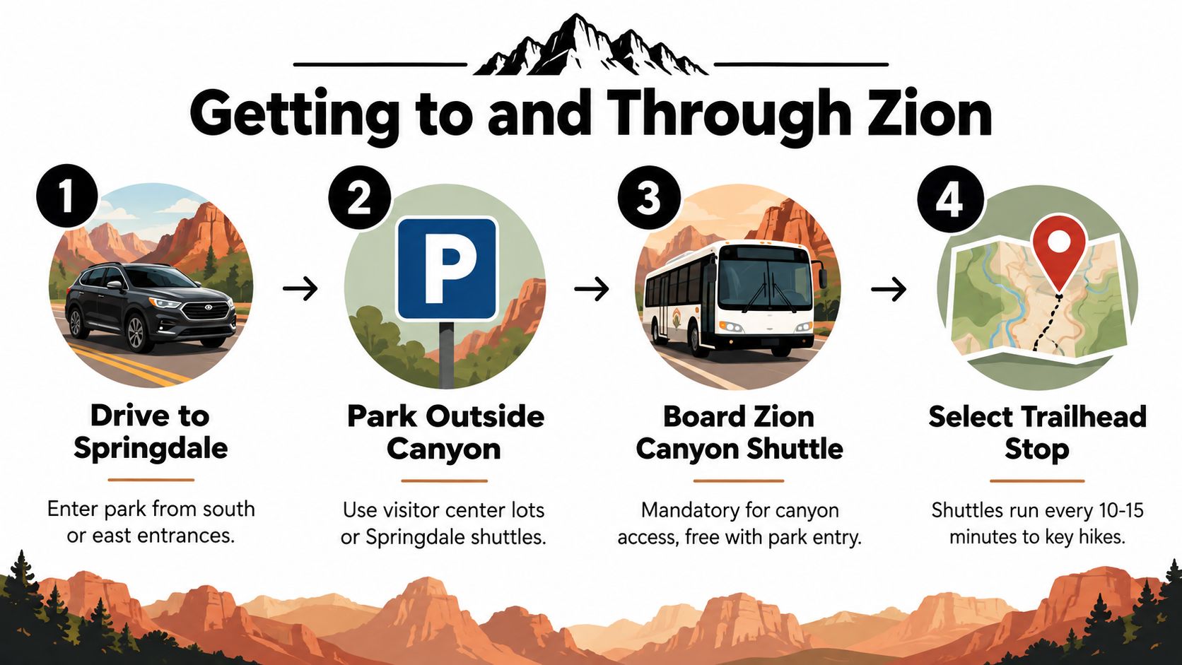
Treat Springdale as the staging area for your canyon day. Drive to the town or the park's south entrance, locate legal parking, and build the shuttle ride into the itinerary before you start walking. During scheduled shuttle operations, private vehicles don't provide a dependable way to reach Zion Canyon trailheads.
The park's 2026 shuttle schedule states that service resumes on March 7, 2026. During scheduled hours, Zion Canyon shuttles arrive about every five to 10 minutes, while Springdale shuttles arrive about every 10 to 15 minutes, according to the official 2026 shuttle announcement.
Use an if-then arrival plan
- If you're staying in Springdale, consider leaving the car at your lodging and using the town shuttle or walking to the pedestrian entrance when service and conditions permit.
- If you plan to park inside the park, arrive with enough flexibility to use an alternative legal parking location if the preferred area is full.
- If your hike begins in Zion Canyon, board the Zion Canyon shuttle and identify the correct stop before you enter the canyon.
- If your route is permit-controlled, keep the permit accessible. Shuttle drivers may verify permits for certain trailheads before allowing drop-off, as described in the 2026 Zion operating plan.
The shuttle is free with park entry, but “free” doesn't mean frictionless. You still need to account for boarding queues, stop selection, and the time required to return from the trailhead. For a cross-state road trip, these same arrival principles can help structure a Las Vegas travel guide beyond the Strip, especially when a major attraction has controlled access.
Write down your outbound stop and your return stop. That small habit prevents confusion when you're tired, the canyon light is changing, and several groups are waiting at the same platform.
Permits and Access Rules That Change by Trail
Zion works like a trail-by-trail access system. A route's permit requirement, shuttle connection, and river conditions can determine whether your plan works, sometimes more than distance or fitness.
Angels Landing requires a permit for anyone continuing beyond Scout Lookout onto the chain section. The National Park Service Angels Landing permit page describes seasonal lotteries and a day-before lottery. The day-before lottery opens at 12:01 a.m. Mountain Time and closes at 3 p.m. Mountain Time. Apply through Recreation.gov's Angels Landing system. Everyone hiking Angels Landing must carry the required permit.
For 2026, seasonal lottery windows cover spring hiking dates from March 1 through May 31, summer dates from June 1 through August 31, fall dates from September 1 through November 30, and winter dates from December 1 through February 28, 2027, subject to updates in the park's 2026 announcement.
Compare routes before you reserve
| Trail or Route | Permit Required | Access Notes |
|---|---|---|
| Angels Landing chain section | Yes | Permit required beyond Scout Lookout, with seasonal and day-before lottery options |
| Narrows bottom-up from Temple of Sinawava | No wilderness permit | Access depends on shuttle operations, river flow, and current conditions |
| Narrows top-down from Chamberlain's Ranch | Yes | The 16-mile through-hike requires a wilderness permit and coordinated transportation |
| Subway through-hike | Yes, route-specific | Wilderness or canyoneering rules apply, and conditions can close the route |
| Other canyon trails | Varies | Check the current trail and permit status before boarding |
The bottom-up Narrows is simpler to arrange because it starts at Temple of Sinawava and does not require a wilderness permit. The top-down route demands a different plan: a 16-mile commitment, a permit, transportation coordination, and a top-down access limit of 120 cubic feet per second for permits issued through Recreation.gov's Narrows permit information.
A permit authorizes access under the applicable rules, but it cannot override weather, river discharge, closures, or shuttle operations. Check the route status immediately before departure, then keep a backup hike that does not depend on the same condition. That final check turns your permit from a reservation into a workable day plan.
Best Zion Hikes by Difficulty Time and Route Tips
A good Zion hike matches your physical capacity, available time, and the day's access conditions. Route choice works like a three-part filter. First assess the terrain, then the time required, then whether the shuttle, permit, and river conditions allow the plan. A short paved walk can be the better decision if a late shuttle arrival leaves little time for the return.
Match the route to the day
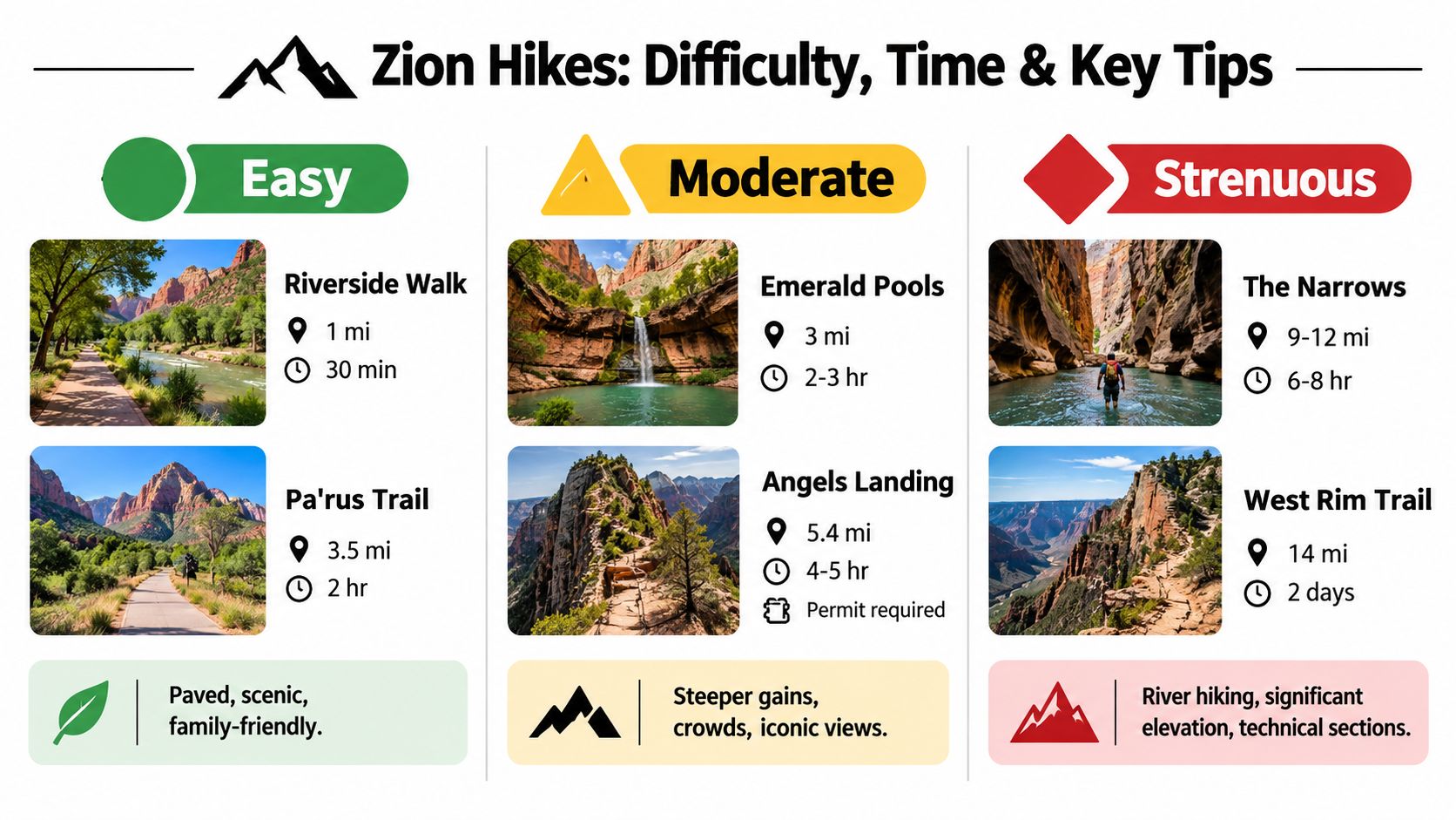
Easy routes suit families, recovery days, and visitors who want canyon scenery without exposed terrain. Riverside Walk follows the canyon toward the Narrows, while Pa'rus Trail provides a paved route beside the Virgin River. These walks also help first-time visitors understand how the canyon, shuttle stops, and river corridor connect.
Moderate routes add climbing and longer movement. Emerald Pools offers a defined objective without a chain section. Angels Landing requires more caution than its approach may suggest. The final section is permit-controlled and exposed, so hikers need steady footing, patience, and enough space from others.
Strenuous routes require a complete logistics check before departure. The Narrows involves river travel, while the West Rim Trail represents a substantial commitment that may call for an overnight plan. Choose the route you can finish with time for the return shuttle, rather than turning the final miles into a race.
Footwear should match the surface and water exposure. Hikers comparing lightweight trail runners with more structured footwear can review trail runners vs hiking boots before choosing shoes for rocky approaches and wet routes.
Read conditions as part of difficulty
Zion's shuttle system has shaped canyon access for decades. Arriving at the correct stop and allowing time for the ride can matter as much as following the trail. Build a time cushion into hikes that begin deep inside the canyon, especially when the return depends on a scheduled shuttle.
That timing changes the practical difficulty of a route. A short hike with a narrow transportation window may demand more planning than a longer walk near an accessible stop. Check the day's shuttle plan before setting out and keep a nearby alternative in mind.
On Angels Landing, turn around if exposure, crowding, or declining concentration makes the chain section unsafe. On the Narrows, distance is only one part of the challenge. Water depth, current strength, cold, and the ability to retreat can determine whether the route is suitable that day.
For regional comparisons, this guide to the best hiking trails in Colorado for every skill level reinforces a useful principle: difficulty labels begin the decision, while terrain and current conditions finish it.
Safety Seasonal Hazards and Dynamic Closures
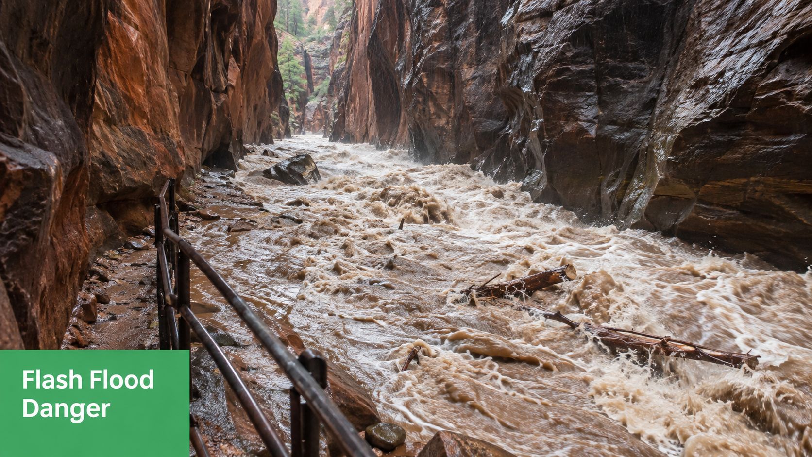
Zion's conditions can invalidate a well-built plan quickly. The pre-hike routine should include the current weather alert, trail status, river discharge, and any route-specific closure rule. Don't rely on yesterday's report, a social media post, or a trail ranking written for a different season.
Apply clear go or no-go checks
The park's 2025 compendium states that the North Fork of the Virgin River above Big Spring closes to hiking when flow exceeds 120 cubic feet per second, all canyons close when a flood warning is issued, and Subway through-hikes are blocked when snow-water equivalent at Kolob exceeds 35 inches, according to the 2025 Superintendent's Compendium.
These rules turn vague caution into an operational decision:
- River route: Stop and reassess when the applicable flow threshold closes the route.
- Canyon route: Treat a flood warning as a complete no-go for canyon travel.
- Subway route: Verify the Kolob snow-water condition before setting out.
- Any route: Replace a closed plan rather than trying to find an unofficial way around the restriction.
Pack according to the hazard. Summer hikers need sun protection and reliable water carrying capacity. Cold-season Narrows hikers need equipment appropriate for cold water and slippery surfaces. Anyone entering a canyon should have a turnaround plan that doesn't depend on perfect weather.
Weather rule: A permit or an open trail at breakfast doesn't override a flood warning later in the day.
The park has also experienced active operational changes, including the reopening of Weeping Rock Trail and Shuttle Stop 7 in September 2025 and a shuttle season resuming in March 2026, so current status checks matter more than static lists. For a similar approach to changing conditions in another area, review this guide to Theodore Roosevelt National Park.
Packing Gear Checklist and Accessibility Essentials
Pack for the route you have, not the route you originally imagined. A paved walk needs different support from a chain hike or river corridor, and winter conditions can change the footwear decision before you reach the trailhead.
- Footwear: Use secure, well-tested shoes with traction. Avoid bringing new footwear on a demanding route.
- Water and food: Carry enough for your planned effort, heat exposure, and delays.
- Sun and layers: Bring sun protection for exposed sections and an insulating layer for changing canyon temperatures.
- Narrows equipment: Check current conditions before choosing river footwear or cold-water protection. The National Park Service conditions page states that the Narrows closes above 150 cubic feet per second, while upstream travel becomes challenging above 70 cubic feet per second, with mid-thigh to chest-deep crossings becoming common.
- Small essentials: A compact bag with a stable water-bottle holder can make hydration easier on moving terrain. This guide to the best bag for a water bottle can help you compare practical designs.
Visitors seeking lower-barrier options should prioritize paved routes, accessible viewpoints, and shuttle stops that reduce unnecessary walking between transport and trail access. Confirm current conditions for any route before arrival, especially if mobility needs make an unexpected reroute difficult.
Where to Stay Itineraries and Sustainable Travel in Zion
Springdale is a practical base because it places lodging, food, and shuttle access close to the park entrance. Staying inside the park can reduce morning movement, while camping offers a more immediate connection to the canyon. The right choice depends on whether your priority is early access, comfort, or a slower multi-day rhythm.
For a focused day, choose one primary route and one flexible scenic walk. A longer visit can pair a permit hike on one day with the Narrows or a lower-commitment canyon route on another, leaving room for changing conditions.
Use a repeatable final check
- Confirm the shuttle schedule and your planned boarding point.
- Verify every permit requirement by trail, not by park.
- Check river discharge and weather warnings for water or canyon routes.
- Review current closures before leaving lodging.
- Carry out waste, stay on designated routes, and respect wildlife and other hikers.
- Keep a backup route that uses different access conditions.
Travelers extending a Southwest itinerary can use this Mount Rushmore travel guide and nearby attractions for another destination-planning reference. The same principle applies everywhere: responsible travel protects the place and gives you a better chance of returning to the experience you came for.
Reworx Recycling helps businesses responsibly manage old computers, laptops, servers, and other electronics through donation-based recycling, secure data destruction, business pickups, and IT asset disposition services. If your organization is planning an office cleanout, facility cleanout, or technology upgrade, visit Reworx Recycling to donate equipment, schedule a pickup, or explore a community-focused recycling partnership.